Introducing MILO: Revolutionizing Map-Based Data Exploration
MapMetrics has introduced MILO, our AI-powered data explorer, designed to transform the way insights are visualized on maps. Fully integrated into the MapMetrics mapping ecosystem, MILO is set to simplify and enhance data analysis by converting complex datasets into interactive, map-based visualizations. This new tool not only turns cumbersome spreadsheets into dynamic visual maps but also brings a fresh, user-friendly approach to exploring real-world data.
The Concept Behind MILO
MILO is conceived as a smart companion—imagine a bright, eager puppy in its Alfa training phase. Though his playful demeanor suggests an approachable nature, MILO is built on robust Tecnologia AI capable of deep data analysis. He is engineered to learn and evolve, much like a young pup growing into a reliable partner in data exploration. This dual character means that while MILO offers a friendly interface, he also packs the analytical power needed to uncover hidden trends and patterns within extensive datasets.
Streamlining Data Analysis
Traditional data analysis often requires tedious manual work—navigating endless spreadsheets, performing countless calculations, and making decisions based on static reports. MILO eliminates these challenges by automating the process of converting raw data into visually intuitive maps. With advanced algorithms at his core, MILO filters and processes large volumes of information, presenting users with clear visual insights that highlight key trends and anomalies.
This automation means that users can bypass the laborious number-crunching stage and instead focus on what truly matters: making informed decisions. By transforming complex data into interactive maps, MILO offers a more immediate and engaging understanding of information, saving time and reducing errors that often come with manual data handling.
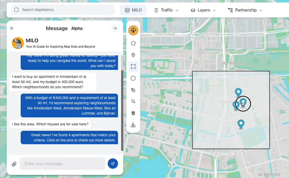
Real-World Test: The Amsterdam Housing Market
MILO’s first test showcased his potential in a practical setting. During this initial trial, MILO was tasked with exploring housing options in Amsterdam based on a €400,000 budget for a 50 m² apartment. The test involved searching through various neighborhoods, where MILO quickly identified promising locations such as Amsterdam West, Nieuw-West, Bos en Lommer, and Bijlmer. See MILO in action in this video.
Beyond simply listing potential areas, MILO also provided critical insights by flagging an apartment that was priced 12.6% above the average. This real-time alert demonstrated MILO’s ability to not only locate options but also to advise users on pricing discrepancies. This example serves as a testament to MILO’s capability to offer practical, actionable insights, making the home search process both efficient and informed.
Expanding Data Exploration Potential
One of MILO’s most exciting prospects lies in his ability to help users search for all types of data available on the map and from real-life streets and cities. Beyond the housing market, MILO can be harnessed to explore a diverse array of information including restaurants, price comparisons, and neighborhood details in real-time. This functionality means that whether you are a business owner seeking competitive pricing data, a resident scouting for the best dining options, or a traveler looking to explore a city, MILO can serve as a comprehensive guide.
Imagine navigating a city map where every restaurant, street detail, and neighborhood characteristic is dynamically updated. MILO’s integration of live data streams allows him to provide real-time information on various urban elements, transforming the traditional static map into an interactive tool that reflects the pulse of city life. By visualizing such data directly on the map, MILO empowers users to make timely decisions based on the most current insights available.
Enhancing Map-Based Visualization
MILO’s strength is further amplified through his seamless integration with the MapMetrics ecosystem. This connection not only ensures that the visualizations are accurate and up-to-date but also enhances the overall user experience by presenting data in a visually appealing and accessible format. With MILO, traditional maps are turned into dynamic canvases where users can easily discern geographical patterns and trends.
Interactive map-based visualization has a significant advantage over conventional charts and tables. It provides a spatial context that is crucial for understanding how data points relate to one another geographically. This feature is particularly valuable in scenarios where location-based insights—such as regional pricing differences or neighborhood popularity—play a pivotal role in decision-making.
Future Developments and Strategic Collaborations
While MILO’s first test in the Amsterdam housing market has already demonstrated his practical value, his potential is far-reaching. The development roadmap for MILO includes continuous enhancements and the integration of more diverse data sources. Future updates will further expand his functionalities, allowing him to cover an even broader spectrum of real-life data, from urban amenities to commercial trends.
In addition, MapMetrics is actively collaborating with partners like DePINs to harness the combined power of live data and mapping technology. This collaboration aims to showcase the remarkable benefits of merging detailed, real-time data with interactive map visualizations, making advanced analytical tools accessible to a wider audience. Through these strategic partnerships, MILO is set to evolve into an indispensable asset for professionals and everyday users alike.
Conclusione
MapMetrics has taken a significant step forward with the introduction of MILO, an AI-powered data explorer that redefines the boundaries of map-based visualization. From his impressive first test in Amsterdam to his potential for real-time data searches—including information on restaurants, prices, and neighborhoods—MILO exemplifies the future of interactive data analysis. By automating the process of data conversion and enhancing it with dynamic, real-world insights, MILO not only simplifies data exploration but also empowers users to make smarter, more informed decisions.
As MILO continues to evolve, its capabilities will expand, offering even more comprehensive tools to navigate the complexities of urban data. Whether for real estate, urban planning, or everyday exploration, MILO is poised to become a vital tool in the modern data landscape. Stay tuned as we continue to develop MILO’s features and explore the exciting possibilities of map-based data exploration.